PACIFIC DISASTER UNFOLDS: MASSIVE SEISMIC EVENT TRIGGERS DEVASTATING TSUNAMI ACROSS THOUSANDS OF MILES
A catastrophic natural disaster has unleashed unprecedented chaos across the Pacific Basin as a powerful seismic event generates destructive tsunami waves that have traveled thousands of miles, impacting coastal communities from the remote Russian wilderness to the bustling shores of California. The magnitude and scope of this oceanic catastrophe have prompted emergency declarations, mass evacuations, and international cooperation efforts on a scale rarely witnessed in modern disaster response history.
REMOTE GEOLOGICAL VIOLENCE TRIGGERS INTERNATIONAL CRISIS
The origins of this devastating Pacific-wide disaster trace back to the remote and sparsely populated Kamchatka Peninsula, a rugged landmass extending into the frigid waters of the North Pacific Ocean where Russia’s easternmost territories meet the volatile geological forces that define the Pacific Ring of Fire. This desolate region, characterized by active volcanoes, pristine wilderness, and minimal human habitation, became the epicenter of a geological event that would impact millions of people across multiple nations and territories.
The Kamchatka Peninsula’s position at the intersection of several major tectonic plates creates one of Earth’s most geologically active and unpredictable regions, where massive underground forces constantly reshape the landscape through volcanic eruptions, earthquakes, and other seismic phenomena. The peninsula’s rugged terrain, dominated by volcanic peaks and deep valleys carved by ancient glacial activity, sits atop a complex network of fault lines and magma chambers that occasionally release enormous amounts of energy in sudden, violent episodes.
On the morning of July 29, 2025, this geological tinderbox exploded with devastating force as tectonic plates shifted dramatically beneath the ocean floor, displacing massive volumes of seawater and creating the conditions for tsunami generation on an unprecedented scale. The sudden vertical movement of the seafloor acted like an enormous underwater piston, pushing vast quantities of ocean water outward in all directions across the Pacific Basin with tremendous force and velocity.
Seismologists monitoring this remote region through a network of sophisticated instruments detected the massive earthquake within minutes of its occurrence, immediately recognizing the potential for far-reaching tsunami generation based on the event’s magnitude, depth, and underwater location. The geological characteristics of this particular earthquake created optimal conditions for tsunami formation, combining powerful seismic energy with efficient water displacement mechanisms that would send destructive waves racing across thousands of miles of open ocean.
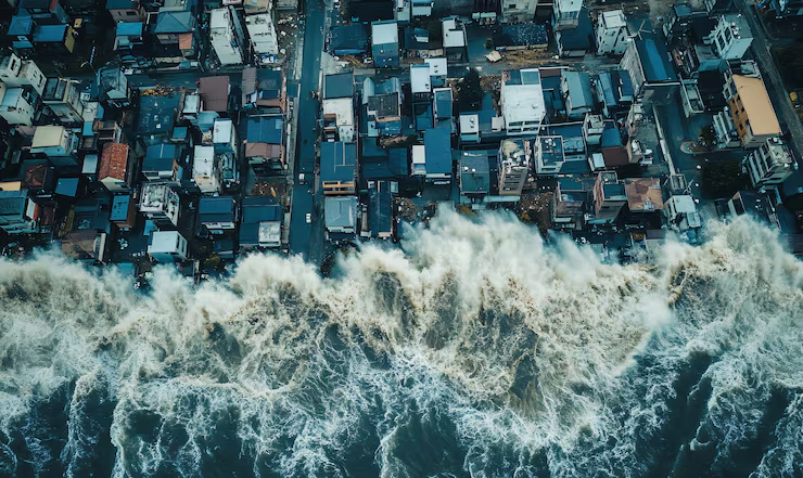
TSUNAMI PROPAGATION MECHANICS DEMONSTRATE OCEANIC POWER
The physics governing tsunami propagation across vast oceanic distances reveal the awesome power of these natural phenomena and their ability to maintain destructive energy across thousands of miles of travel. Unlike conventional wind-driven waves that affect only surface waters, tsunami waves involve the entire water column from seafloor to surface, creating massive moving walls of water that can travel at speeds approaching 500 miles per hour in deep ocean environments.
The Pacific Tsunami Warning Center in Honolulu, Hawaii, immediately activated comprehensive monitoring protocols using an extensive network of deep-ocean detection buoys, coastal monitoring stations, and satellite communication systems that provide real-time data on wave characteristics, propagation patterns, and arrival time predictions for vulnerable coastal communities across the Pacific Basin.
Advanced computer modeling systems at the warning center processed seismic data and bathymetric information to generate detailed predictions of wave behavior, timing, and potential impact zones throughout the Pacific region. These sophisticated forecasting tools combine real-time seismic measurements with extensive databases of ocean floor topography, coastal geography, and historical tsunami behavior patterns to produce increasingly accurate warnings and evacuation recommendations.
The underwater topography of the Pacific Ocean played a crucial role in determining wave propagation patterns and impact intensity across different coastal regions. Underwater ridges, seamounts, continental shelves, and deep ocean trenches all influenced the direction, speed, and focusing of tsunami energy as waves spread outward from their source near Kamchatka, creating complex patterns of wave amplification and dispersion across the vast oceanic basin.
HAWAIIAN ISLANDS BEAR INITIAL DEVASTATING IMPACT
Hawaii’s central position in the Pacific Ocean and its volcanic island topography made it among the first major populated areas to experience the full force of the approaching tsunami waves, with different locations across the island chain recording dramatically varying wave heights based on their geographic orientation, coastal configuration, and underwater approach paths.
Kahului, located on the northern shore of Maui, experienced the most severe impact across all affected areas, with tide gauge measurements recording devastating waves reaching 5.7 feet above normal sea level. The geographic configuration of Kahului Bay, with its wide northern opening directly facing the tsunami source region, created optimal conditions for wave focusing and amplification as the oceanic energy converged on this vulnerable coastal community.
The town of Hilo on Hawaii’s Big Island, bearing the tragic historical legacy of devastating tsunami impacts in 1946 and 1960 that killed dozens of residents and destroyed much of the community’s downtown area, recorded waves measuring 4.9 feet above normal levels. The community’s extensive tsunami preparedness infrastructure, including comprehensive evacuation zones, advanced warning systems, and well-trained emergency response protocols, reflected decades of lessons learned from previous oceanic disasters.
Additional Hawaiian locations experienced varying degrees of tsunami impact based on their coastal orientation and geographic characteristics. Haleiwa, situated on Oahu’s famous North Shore, recorded waves measuring 4.0 feet, while the picturesque community of Hanalei on Kauai’s northern coast measured waves reaching 3.9 feet above normal sea levels, demonstrating the complex interactions between tsunami energy and Hawaii’s diverse coastal topography.
Hawaiian emergency management officials had issued comprehensive tsunami warnings across all islands, prompting immediate evacuation of low-lying coastal areas, closure of beaches and harbors, and activation of well-rehearsed emergency protocols developed through decades of Pacific tsunami preparedness. Emergency sirens echoed across island communities while broadcast systems provided continuous updates and evacuation instructions to residents and visitors in vulnerable coastal zones.
CALIFORNIA COASTLINE FACES UNPRECEDENTED TSUNAMI THREAT
California’s extensive 800-mile coastline, stretching from the Mexican border to Oregon and encompassing diverse coastal environments from sandy beaches to rocky cliffs to protected bays and harbors, presented emergency management officials with complex challenges in predicting and responding to approaching tsunami waves across numerous distinct geographic regions.
Crescent City, located in far northern California near the Oregon border, recorded the highest tsunami waves along the entire continental United States coastline, measuring 4.0 feet above normal sea level. This small coastal community’s unique vulnerability to tsunami impacts stems from its location at the mouth of the Klamath River and its relatively flat coastal topography that provides minimal natural protection from oceanic surges.
The city’s harbor complex, extending inland from the ocean through a narrow channel, created conditions that could potentially amplify and focus tsunami energy as waves moved upstream, threatening both waterfront infrastructure and inland areas that might normally be considered safe from oceanic threats. Local emergency management officials coordinated evacuation efforts with state and federal agencies to ensure vulnerable populations reached safe elevations before wave arrival.
Arena Cove, a small inlet along California’s rugged Mendocino Coast, experienced tsunami waves measuring 3.0 feet above normal levels. Despite its remote location and sparse population, this coastal monitoring point provides crucial data for understanding tsunami behavior along California’s northern coastline, where rocky terrain and steep coastal cliffs offer natural protection from wave penetration but create complex reflection and refraction patterns.
Washington and Oregon’s Pacific coastlines also experienced significant tsunami impacts, though generally with lower wave heights than their California neighbors. The complex coastal geography of the Pacific Northwest, characterized by numerous inlets, bays, river mouths, and protected waterways, created highly variable conditions for tsunami impact assessment and emergency response coordination.
ALASKAN COMMUNITIES DEMONSTRATE RESILIENCE
Despite Alaska’s geographic proximity to the earthquake source region near Russia’s Kamchatka Peninsula, the state experienced relatively modest tsunami impacts due to the specific geometry of the seismic event and the complex underwater topography between the earthquake epicenter and Alaskan coastal communities.
Adak, located in the remote Aleutian Islands chain, recorded tsunami waves measuring 2.7 feet above normal sea level. This measurement, while significant for local conditions, represented lower impact levels than initially feared given the community’s closeness to the tsunami source region and its position along the same tectonic system responsible for generating the destructive earthquake.
The Aleutian Islands’ formation through volcanic activity along the Pacific Ring of Fire creates a unique geological relationship with the same tectonic forces that generated the Kamchatka earthquake. Residents of these remote island communities maintain extensive experience with earthquake and tsunami preparedness protocols, even in locations with limited infrastructure and challenging communication conditions.
Alaska’s vast coastline, extending for thousands of miles and including numerous fjords, bays, islands, and remote settlements, presents extraordinary challenges for comprehensive tsunami monitoring and emergency response coordination. The state’s sparse population distribution and isolated communities mean that accurate wave measurements and damage assessments often require extended time periods, particularly in areas accessible only by boat or aircraft.
COORDINATED EMERGENCY RESPONSE DEMONSTRATES INTERNATIONAL COOPERATION
The comprehensive response to this Pacific-wide tsunami event showcased the effectiveness of modern international warning systems and emergency management protocols developed through decades of scientific cooperation and disaster preparedness investment. The Pacific Tsunami Warning Center, operated by the National Weather Service, serves as the primary coordination hub for tsunami information sharing across the entire Pacific Basin.
This sophisticated monitoring network includes seismic detection stations, deep-ocean buoy systems, coastal tide gauges, and satellite communication links that enable real-time data collection and analysis from across the vast Pacific region. Advanced computer modeling systems process this information to generate accurate wave arrival predictions, impact assessments, and evacuation recommendations for vulnerable coastal communities.
Hawaii’s emergency management system demonstrated remarkable coordination and effectiveness, with Governor Josh Green working closely with federal officials including Homeland Security Secretary Kristi Noem to ensure appropriate resources were available and evacuation procedures could be modified as real-time conditions evolved. This flexible response capability reflected years of preparation and regular training exercises designed to address various tsunami scenarios.
The decision-making process for modifying warning levels from initial alerts to advisories required careful analysis of actual wave measurements compared to computer model predictions. Emergency officials must balance legitimate public safety concerns with the significant economic and social disruption caused by extended evacuations, beach closures, and harbor restrictions that affect tourism, commerce, and daily life across affected communities.
PUBLIC PREPAREDNESS SAVES LIVES ACROSS AFFECTED REGIONS
The remarkably low casualty rates despite significant tsunami impacts across multiple countries demonstrated the critical importance of public education, community preparedness, and individual compliance with emergency evacuation orders and safety recommendations. Years of investment in tsunami awareness programs, regular emergency drills, and community education initiatives contributed to orderly and effective responses across all affected coastal areas.
Modern communication systems, including social media platforms, emergency alert networks, and traditional broadcast media, enabled rapid dissemination of critical safety information to residents and visitors in vulnerable coastal zones. These communication capabilities allowed emergency managers to provide real-time updates on changing conditions, evacuation status, and safety recommendations as the tsunami event unfolded over several hours.
Community preparedness programs that emphasize personal responsibility, family emergency planning, and neighborhood mutual assistance proved essential in ensuring effective evacuation and safety compliance across diverse populations including permanent residents, tourists, and temporary visitors who might be unfamiliar with local emergency procedures and evacuation routes.
The effectiveness of public response also reflected cultural changes in disaster preparedness attitudes, with increased awareness of natural disaster risks and greater willingness to comply with official evacuation orders and safety recommendations. This cultural shift toward preparedness and personal responsibility represents a significant achievement in public safety education and community resilience building.
SCIENTIFIC RESEARCH ADVANCES TSUNAMI UNDERSTANDING
This major tsunami event provided unprecedented opportunities for scientific data collection and analysis that will contribute to improved understanding of wave propagation mechanics, coastal impact assessment, and emergency response effectiveness across diverse geographic and demographic conditions.
The extensive network of monitoring instruments deployed throughout the Pacific Basin captured detailed measurements of wave characteristics, timing variations, and geographic impact patterns that will enhance computer modeling capabilities and improve future tsunami forecasting accuracy. This comprehensive data collection represents one of the most complete scientific documentation efforts ever achieved for a major Pacific-wide tsunami event.
Research teams from multiple countries coordinated data sharing and analysis efforts to maximize the scientific value of this natural disaster, recognizing that improved understanding of tsunami mechanics benefits all Pacific Rim communities regardless of political boundaries or national affiliations. International scientific cooperation in disaster research demonstrates the global nature of natural hazard threats and the mutual benefits of shared knowledge and expertise.
The relatively limited structural damage despite significant wave heights provided valuable insights into the effectiveness of various coastal protection measures, building design standards, and land use planning approaches in reducing tsunami vulnerability. These lessons will inform future coastal development policies and infrastructure investment priorities across tsunami-prone regions.
ECONOMIC IMPACTS EXTEND BEYOND IMMEDIATE COASTAL DAMAGE
The economic consequences of this Pacific-wide tsunami extended far beyond immediate physical damage to coastal infrastructure, encompassing disruptions to tourism, maritime commerce, fishing operations, and international trade relationships that connect Pacific Rim economies through complex supply chains and commercial partnerships.
Coastal businesses across affected regions faced immediate losses from mandatory closures, evacuation requirements, and post-tsunami safety inspections that interrupted normal operations during peak summer tourism and recreational seasons. Hotels, restaurants, retail establishments, and recreational facilities in coastal zones experienced significant revenue losses during critical periods of their annual business cycles.
Maritime operations including commercial shipping, fishing fleets, recreational boating, and port facilities required comprehensive inspection and clearance procedures before resuming normal operations. Harbors and marinas needed detailed assessment for structural damage, debris accumulation, and changes in underwater conditions that could affect navigation safety and operational efficiency.
The international nature of Pacific commerce means that tsunami-related disruptions in one region can cascade through global supply chains, affecting manufacturing, retail, and service industries far from the immediate impact zones. Recovery planning must consider these interconnected economic relationships and the time required for full restoration of normal commercial activities.
CLIMATE CHANGE IMPLICATIONS INTENSIFY FUTURE TSUNAMI RISKS
The intersection of natural tsunami hazards with ongoing climate change impacts creates increasingly complex challenges for coastal communities already facing sea level rise, coastal erosion, and changing storm patterns that affect vulnerability to oceanic disasters. Rising baseline sea levels mean that tsunami waves of any given height will penetrate farther inland and cause more extensive flooding than similar events in previous decades.
Coastal development patterns established during periods of stable sea levels may become increasingly vulnerable as climate change alters baseline oceanic conditions and extreme weather patterns. Communities must consider these changing baseline conditions when evaluating tsunami evacuation routes, safe zone boundaries, and infrastructure protection measures.
The potential for climate change to affect the frequency or intensity of geological events remains a subject of ongoing scientific research, with some studies suggesting that changing ice loads and sea levels might influence tectonic stress patterns in certain regions. While these relationships remain uncertain, the precautionary principle suggests that coastal communities should prepare for potentially changing natural hazard patterns.
Adaptation strategies for climate change and tsunami preparedness often involve similar approaches including elevated infrastructure, flexible evacuation systems, and resilient communication networks that can function effectively under various disaster scenarios. Integrated planning approaches that address multiple hazards simultaneously may prove more cost-effective and environmentally sustainable than separate mitigation efforts.
INTERNATIONAL COOPERATION MODELS FOR FUTURE DISASTER RESPONSE
The successful coordination of tsunami response across multiple countries and jurisdictions demonstrated the value of international cooperation frameworks and shared responsibility for Pacific-wide disaster preparedness and response capabilities. These collaborative relationships provide models for addressing other transnational challenges including climate change, pandemic response, and technological disasters.
The Pacific Tsunami Warning Center’s role as a multinational coordination hub illustrates how scientific expertise and technological capabilities can be shared effectively across political boundaries to serve common safety interests. This institutional model could be adapted for other global challenges requiring rapid information sharing and coordinated response capabilities.
Diplomatic relationships between Pacific Rim nations proved essential for facilitating information sharing, resource coordination, and mutual assistance during the tsunami emergency. These relationships, built through years of cooperation in various fields, provided the foundation for effective disaster response when rapid action was essential for protecting vulnerable populations.
The lessons learned from this international disaster response will inform future cooperation agreements and institutional development efforts aimed at building resilience against various natural and technological hazards that affect multiple countries simultaneously.
CONCLUSION: RESILIENCE TRIUMPHS OVER NATURAL CATASTROPHE
The devastating Pacific tsunami generated by the Kamchatka Peninsula earthquake ultimately demonstrated both the awesome destructive power of natural forces and the remarkable resilience of modern societies equipped with advanced warning systems, effective emergency management protocols, and well-prepared communities committed to mutual safety and support.
The successful limitation of casualties despite significant wave impacts across thousands of miles of coastline validates decades of investment in tsunami science, warning technology, emergency preparedness, and public education initiatives that have transformed Pacific Rim communities’ ability to respond effectively to oceanic disasters.
The international cooperation that characterized this disaster response provides hope for addressing other global challenges requiring coordinated action across political boundaries and cultural differences. The shared commitment to protecting vulnerable populations regardless of nationality or political affiliation demonstrates humanity’s capacity for collaboration in the face of natural disasters.
As Pacific Rim communities begin recovery and rebuilding efforts, the lessons learned from this major tsunami event will inform future preparedness initiatives, infrastructure development, and land use planning decisions that must account for both current hazard patterns and the changing conditions anticipated from ongoing climate change and sea level rise.
The scientific knowledge gained from this event will contribute to improved tsunami warning capabilities, more accurate impact prediction systems, and enhanced emergency response protocols that will benefit all Pacific communities for generations to come. The ultimate legacy of this natural disaster may be measured not only in immediate damage and recovery costs but in the enhanced resilience and preparedness capabilities that emerge from the shared experience of successfully confronting oceanic catastrophe through collective action and mutual support.